
Reduction Blazers
Welcome aboard pals!
Today, you will see the beauty of being prepared!
Naimbag a Bigatmo!
Welcome to Kalinga, Benguet
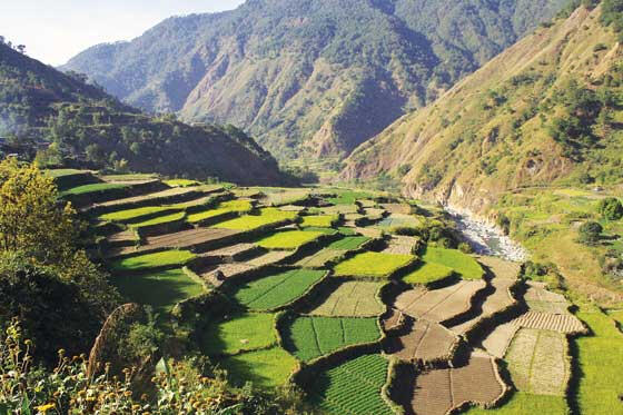
-Benguet, officially the Province of Benguet, is a landlocked province of the Philippines located in the southern tip of the Cordillera Administrative Region in the island of Luzon. Its capital is La Trinidad.
-The highland province is known as the Salad Bowl of the Philippines due to its huge production of upland vegetables
-Situated within the interior of Benguet is the highly urbanized city of Baguio, which is administered independent from the province.
Geography and Climate
-Benguet covers an area of 2,769.08 square kilometres (1,069.15 sq mi) occupying the southwestern tip of the Cordillera Administrative Region. If Baguio City is included for geographical purposes, the total area of Benguet is 2,826.59 square kilometres (1,091.35 sq mi).
-The province is bordered on the northeast by Mountain Province and Ifugao, on the southeast by Nueva Vizcaya, on the south by Pangasinan, on the west by La Union, and on the northwest by Ilocos Sur.
-Situated within the Cordillera mountains, Benguet is dominantly mountainous. Mount Pulag, the highest in Luzon is located within Kabayan. The mountains form the headwaters of several rivers, the major ones which include the Agno, Amburayan, Bued, Bakun, Balili and the Asin. Some of these run through river valleys or gorges.
-Several natural lakes, small in size, are found within the hinterlands. The largest are the "Four Lakes" in Kabayan; Lake Bulalacao, Lake Detepngepos, Lake Incolos and Lake Tabeyo.
-Most of Benguet falls under the subtropical highland climate (Köppen Cwb) zone, experiencing annual average highs of 25.3 °C (77.5 °F) in April and lows of 13.3 °C (55.9 °F) in January.
-The province suffers from crop damage resulting from seasonal frost during the cold months of December to March, especially in high-altitude towns such as Atok, Buguias, Mankayan and Kibungan. In February 2007, Benguet suffered crop damage due to temperatures reaching as low as 7 °C (45 °F)
NATURAL DISASTERS
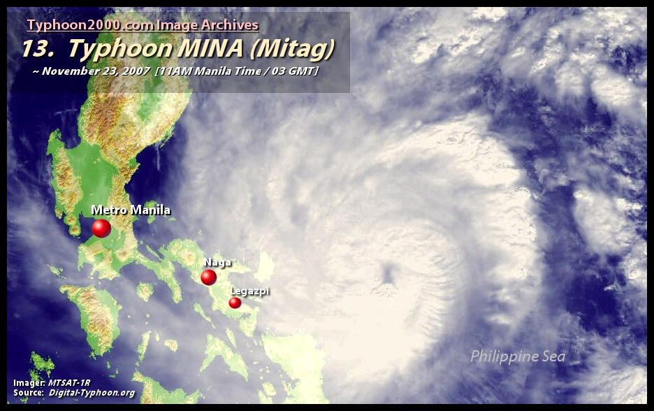
-Typhoon Nanmadol, known in the Philippines as Typhoon Mina, was the strongest tropical cyclone in 2011 to hit the Philippines and also the first of the year to directly impact Taiwan and the rest of the Republic of China (ROC).
-The area of low pressure that was about to become Nanmadol formed on August 19. It drifted north and became a tropical depression on August 21, a tropical storm on August 23, and a typhoon on the same night. Nanmadol reached peak strength with winds of 105 knots (195 km/h; 121 mph) (10-minute sustained) and 140 knots (260 km/h; 160 mph) (1-minute sustained) threatening the Philippines with heavy rain and flash flooding. The Filipinos were warned about high waves, strong winds, and very heavy rains over the weekend with storm signal 4 raised in parts of the Nation. There, strong winds toppled trees, power, and communication lines triggering power outages in the provinces of Cagayan and Isabela. Rivers swelled up on receiving tons on rainwater, overflowing at least six bridges across the two provinces. The typhoon hardly moved in 24 hours bringing relentless rains to the archipelago causing the retaining wall of Baguio's dump facility to collapse. Also, major power lines in the nation were pulled down causing total power failures in Benguet, Cagayan, Apayao, Kalinga, and mountain provinces.

-The death toll for Typhoon Mina casualty was 15; 6 in trash slide, 17 injured, 3 missing and 312 families (7,051 individuals) evacuated due to flooding threats, landslides, and ground subsidence. It also ruined 257 million pesos worth of crops and infrastructures, 23 houses totally damaged and 319 partially damaged. 51 roads closed due to road cuts including 2 major landslides along the Halsema Highway wherein two vehicles were swept to the precipice in their attempt to cross the road cut.
-On August 28, the NDRRMC reported that the typhoon displaced a total of 108,788 people, killing 7, injuring 10, and leaving 6 more missings.
-A total of 93 houses were damaged including 16 totally destroyed. A total of 9 bridges and 28 roads remained impassable as floodwater rushed on top of them. Power was restored to many provinces including Isabela’s communication lines were functional. The only province left without power was Aurora. On August 29, the NDRRMC further upgraded the death toll to 12, the number of injured to 21, and the number of missing to 9. They added that two people from Baguio and Benguet were killed in landslides attributed to Nanmadol.
-DAMAGED HOUSES -A total of 1,753 houses (109 Totally / 1,644 Partially) were damaged in Region I, II, VI, and CAR: (49 totally / 270 partially in Region I; 10 totally / 748 partially in Region II; 4 totally / 7 partially in Region III; 13 totally in Region VI; and 33 totally / 619 partially in CAR)
DAMAGES TO PROPERTIESThe initial cost of damages to infrastructure (roads and bridges, schools) andAgriculture (crops, HVCC, livestock, fisheries, and Agri-infra) amounted to PhP1,432,969,473.39:Infrastructure = PhP 210,976,577.00Agriculture = PhP 1,221,992,896.39
TYPHOON PEDRING
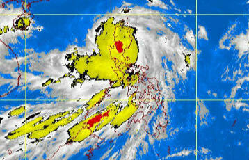
-Typhoon Nesat, known in the Philippines as Typhoon Pedring, was the most powerful tropical cyclone to directly impact China since 2005. It also struck the Philippines during the 2011 Pacific typhoon season, killing 83 people. Typhoon Pedring (Nesat) and Quiel (Nalgea) hit the region on September 25- 27, 2011, and September 30 – October 1, 2011, respectively.
-The two typhoons put most of the provinces in the region under Tropical Storm Signal # 3. All classes at all levels and government offices were suspended; communications bogged down in Kalinga, Ifugao, Mt. Province, Abra, and in some areas of Benguet. Apayao and Ifugao sustained heavy damages; in fact, Ifugao was isolated for almost a month due to damaged bridges and roads. Damages valued at 243 million pesos worth of agricultural products and infrastructures in the entire region.
-The eye of Typhoon Pedring (international name Nesat) is now over the West Philippine sea after leaving devastation in its wake in Northern and Central Luzon, state weather bureau Philippine Atmospheric, Geophysical and Astronomical Services Administration (PAGASA) said Tuesday afternoon. The typhoon has maintained its strength and is still packing maximum sustained winds of 120 kilometers per hour near the center and gustiness of up to 150 kph. The typhoon is also carrying rainfall estimated from between 15 to 25 mm per hour within its 650-kilometer diameter."Pedring" was spotted 70 km west-northwest of Baguio City as of 4 p.m. Tuesday, according to PAGASA. It is expected to be 450 km west-northwest of Baguio City Wednesday afternoon. Public storm signal warning number 3 remains hoisted over Ilocos Sur, La Union, Benguet, and Pangasinan. The 4 provinces are experiencing wind speeds of up to 185 kph. Meanwhile, signal number 2 is raised over Abra, Apayao, Kalinga, Mountain Province, Ifugao, Nueva Viscaya, Nueva Ecija, Tarlac, and Zambales. The storm signal in Metro Manila, Isabela, Quirino, Aurora, Bulacan, Pampanga, Bataan, Cagayan, and the Babuyan and Calayan group of islands has been lowered to signal number 1."Residents in low lying and mountainous areas under Public Storm Warning Signals are alerted against possible flashfloods and landslides. Likewise, those living in coastal areas are alerted against big waves or storm surges generated by this tropical cyclone," PAGASA said in its latest advisory. The typhoon is also expected to enhance the southwest monsoon and will bring scattered to widespread rains over Southern Luzon and the Visayas, the weather bureau added.

-Four (4) died in Ifugao including 3 children due to fallen tree and landslide, 24 injured and 2 were missing. The report showed that 163 houses were partially damaged and 2 were totally damaged. In Abra 12 schools were partially damaged. The strong winds and rain resulted in flooding in low-lying areas of Benguet and Lowland Tabuk. Vegetables, strawberries, and palay have been submerged thus harvest was reduced significantly.
-The death toll of Typhoon Pedring (international name: Nesat) has risen to 43 as of this morning. 44 people were injured and 30 are reported missing. 204,376 individuals remain displaced due to the massive floods caused by the torrential rains of the typhoon, particularly in Northern and Central Luzon. 986,417 persons in 33 provinces across Luzon were affected. 104 bridges and road sections remain impassable nationwide. 51,500 people remain without power. Dams have also been opened as water levels have reached their spilling levels: Ipo, Angat, Ambuklao, Binga, Magat, San Roque. Santiago City, Isabela; Meycauayan City, Obando, and Calumpit in Bulacan; Olongapo City, Zambales; Tarlac City, Tarlac; Noveleta in Cavite; Nueva Ecija; Dinalupihan, Bataan; Malabon, Navotas, and Marikina in Metro Manila have been declared under a state of calamity. Pedring’s estimated damages to agriculture and infrastructure are Php 3.45 Billion. PRC maintains strict 24-hour monitoring of all situations throughout the country while conducting detailed assessments in close coordination with the National Disaster Risk Reduction and Management Council.
-Typhoons Pedring and Quiel wash out 29 hectares of rice lands along the Chico River in Lowland Tabuk, Kalinga while 9 hectares were left with sand and gravel making it difficult to cultivate. It surpasses the yearly record of three hectares of agricultural land that go with the current of the river. Because of silt deposit, waters of the Chico River find new courses during heavy rains causing flooding of rice lands along its base. Siltation of the Chico River worsened due to uncontrolled illegal cutting of trees in Upper Kalinga in exchange for swift cash from the sale of lumbers.
RAIN INDUCED LANDSLIDES
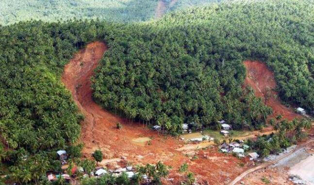
-The Cordillera region is among the top 10 landslide-prone areas in the Philippines. The provinces of Benguet and Mountain Provinces assumed the first and second slots respectively based on a new study of the Department of Environment and Natural Resources (DENR). This situation is attributed to the natural characteristics of the region wherein 90% of its total land area of 1,821,691.98 hectares is characterized by steep to a very steep slope. The mountainous nature is contributory to the region’s vulnerability to rain-induced landslides.
-Rain-induced landslides in the region are widespread. Earth movements happen during heavy rains, the longer rain will hit the region, and the more landslides occur as the soil gets soaked heavy and are loosed during rainy days.
-The human-initiated landslide was due to the reduction of forest cover, at present only 36 % of forest cover remains. Moreover, the remaining forest cover is mostly second-growth trees because the region was covered by many big logging concessions in the past years. The large-scale mining activities also contributed to mountains stripped of forest cover buy cutting trees and open-pit mining activities.
-The slash and burn” agricultural system the upland communities in Kalinga, Mountain Province, Abra, and Benguet is still persistent which in a way contributes to forest degradation. In the vegetable producing areas, expansion towards the forest and watershed areas also add to slimming forest cover and reduction of water supply. Small-scale logging is still prevalent in the remaining forest areas for housing and furniture needs. These malpractices are adding a burden to the worsening environment but can not be preventable because the people need to survive.
-Millions worth of damages were recorded yearly, a significant percentage from the government funds are allocated to respond during emergencies and to repair damages. This year only, 119 million pesos was allocated for the restoration of 2 giant road cuts along the Halsema highway which was caused by typhoon Pepeng in 2009 and aggravated by recent typhoons.
CONCLUSION
-Based on my research, this event is obviously a disaster because as you can see how strong the typhoon is and a lot of people and houses are affected due to this typhoon. Typhoon is a disaster because it impacts human life, property, or livelihood. The greater the number of vulnerable populations living in an at-risk area, the more likely an event will be categorized as a catastrophe.
-Disasters have devastating consequences. They cause death, injury, disease, the destruction of property and other assets, mass displacement, social and economic disruption, loss of infrastructure and other services, and damage to the environment. Poor people living in low and middle-income countries have paid a disproportionate price in terms of human suffering. Their exposure to hazards is exacerbated by poverty, lack of early warning systems, poor risk governance, and an absence of the civil protection mechanisms that are taken for granted in high-income countries. However, while we can’t prevent a hazard from occurring, we can use disaster risk reduction and management to understand risk and vulnerability, prevent a hazard from becoming a disaster, and mitigate its impact by making people more resilient
-Other observations for each situation is that one disaster can create another disaster. Disasters could have an impact to produce other natural disasters. For example, when there is a typhoon there will be a flood, or if there’s an earthquake there will be a tsunami. Some way and somehow the natural disaster have interconnections to each other. Disasters can produce risk and impact on the area and people. Disaster risk is widely recognized as the consequence of the interaction between a hazard and the characteristics that make people and places vulnerable and exposed. Disasters are sometimes considered external shocks, but disaster risk results from the complex interaction between development processes that generate conditions of exposure, vulnerability, and hazard. Disaster risk is therefore considered as the combination of the severity and frequency of a hazard, the numbers of people and assets exposed to the hazard, and their vulnerability to damage. Intensive risk is disaster risk associated with low-probability, high-impact events, whereas extensive risk is associated with high-probability, low-impact events
GRAYLE GAYAGAY- Team Researcher (Kalinga, Benguet)
ED-LOCATIONS
-As our country develops, new challenges comes forth our way and thus we have summarized the places in Luzon where different natural disasters may happen. Our team gathered enough data for you and we have come up with this project. ED- LOCATIONS stands for Event Disaster LOcation towards CAmpaigning Through Internet OptioNS and we are happy to present this informative articles researched by our team.
Our Mission and Vision

The Reduction Blazers has truly become the premier humanitarian organization in the country, committed to provide quality life-saving knowledge that protect the life and dignity especially of indigent Filipinos in vulnerable situations.
Vision
-- Reduction Blazers will lead the way to the future safeness, enriching lives around the world, and to find new ways to move the lives of people.
-- Through our commitment to quality, constant innovation and respect for the society, we aim to exceed expectations and be rewardes with a smile.
Mission
-- We provide solutions and knowledge to people towards one's safeness
--We are a family with a proud heritage passionately committed to providing personal assurance for people around the world.
Reduction Blazers


Troop Leader: Jian Dolosa
Troop assistant leader: Loanne Lou Ruallo
Troop scribe: Kate Arenza, Joseph Bacal and Andrei Lama
Troop Navigators: Grayle Gayagay, John Miguel Ticsay and Laurien Reyes
Taal Volcano Eruption 2020
Description
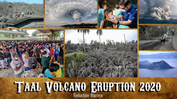
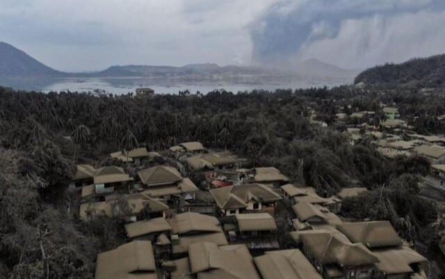
-Taal Volcano and Taal Lake presents one of the most picturesque and attractive views in the Philippines. It is located about 50 kilometers (31 mi) south of the capital of the country, the city of Manila. The main crater of Taal Volcano originally had a lake until the explosive 2020 eruption expelled its water; the lake reformed within months in the rainy climate after activity ceased. The eruption of Taal Volcano in Batangas, Philippines on January 12, 2020, was a phreatomagmatic eruption from its main crater that spewed ashes across CALABARZON, Metro Manila, and some parts of Central Luzon and Ilocos Region, resulting in the suspension of school classes, work schedules, and flights in the area. The Philippine Institute of Volcanology and Seismology (PHIVOLCS) subsequently issued an Alert Level 4, indicating "that a hazardous explosive eruption is possible within hours to days. By January 26, the PHIVOLCS observed an inconsistent, but decreasing volcanic activity in Taal, prompting the agency to downgrade its warning to Alert Level 3. It was until February 14, when the PHIVOLCS finally decided to downgrade the volcano's warning to Alert Level 2, due toits decreasing volcanic activity. As we all know Taal Volcano is an active volcano which can be found in Batangas,Philippines. Its last eruption was dated back in 1977 but still it has a lot of records.
Geology
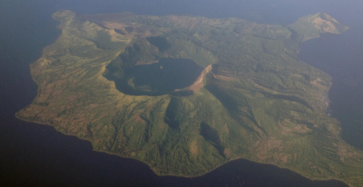
-Taal Volcano and Lake are wholly located in the province of Batangas. The northern half
of Volcano Island falls under the jurisdiction of the lake shore town of Talisay, and the southernhalf to San Nicolas. The other communities that encircle Taal Lake include the cities of Tanauan and Lipa, and the municipalities of Talisay, Laurel, Agoncillo, Santa Teresita, San Nicolas, Alitagtag, Cuenca, Balete, and Mataasnakahoy.
-Permanent settlement on the island is prohibited by the Philippine Institute of Volcanology and Seismology (PHIVOLCS), declaring the whole Volcano Island as a high-risk area and a Permanent Danger Zone (PDZ). Despite the warnings, some families remained settled on the island, risking their lives, earning a living by fishing and farming crops from the rich volcanic soil.
-The Main Crater Lake on Volcano Island is the largest lake on an island in a lake on an
island in the world. Moreover, this lake used to contain Vulcan Point, a small rocky island inside the lake. After the 2020 eruption, the Main Crater Lake have disappeared due to volcanic activity. However the Main Crater Lake returned by March 2020
--Physical profile of the infrastructure in the area--

-Availability of emergency facilities and equipment-

-On 12 January 2020, Taal Volcano in Batangas, Philippines erupted and spewed ash across various parts of Luzon, including CALABARZON and Metro Manila. The Philippine Institute of Volcanology and Seismology (PHIVOLCS) raised the alert level to 4, warning that a hazardous explosion was possible within days or hours. The eruption blanketed in ash the areas on the windfall of Taal
Volcano, with many people exposed to the health risk of inhaling ash particles as well as injuries and other health issues.
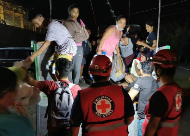
-The Philippine Emergency Medical Assistance Team (PEMAT), led and coordinated by the Department of Health with support from the World Health Organization, answered the call to augment the health response during the Taal Volcano eruption. Emergency medical teams from the Dr Jose N. Rodriguez Memorial Hospital and Sanitarium (DJNRMHS) in Caloocan City in Metro Manila and the Jose B. Lingad Memorial Regional Hospital (JBLMRH) in San Fernando, Pampanga in Central Luzon were deployed to Batangas.
-The team from JBLMRH arrived in Sto. Tomas, Batangas on 15 January, with two rounds of deployment of 17 staff during the first round for 10 days and 18 staff on the second round for 8 days. Meanwhile, the team from DJNRMHS arrived in Balayan, Batangas on 17 January with 27 staff for 14 days. Both teams ended their deployment on 30 January. The health personnel were composed of doctors, nurses, midwives, pharmacists, medical technicians, social workers, logisticians, pharmacists, and administrative staff. Self-sufficiency is crucial during deployment, so the teams brought with them all their needs – from the tents, water supply, generators, beds, medicines, and equipment.
-The volcano erupted on the afternoon of January 12, 2020, 43 years after its previous eruption in 1977. According to PHIVOLCS director Dr. Renato Solidum, seismic swarms began at 11 am and were later followed by phreatic eruption from Volcano Island Main Crater at around 1 pm Philippine Standard Time (UTC+8). Loud rumbling sounds were also felt and heard from the volcano island. By 2:30 pm, the PHIVOLCS raised the alert status to Alert Level 2, although the PHIVOLCS through its Taal Volcano Observatory had advised residents of Volcano Island to evacuate at around 1 pm. Stronger explosions began around 3 pm that spewed an ash column exceeding a kilometer high, prompting the PHIVOLCS to upgrade the alert status to Alert Level 3 by 4 pm. Furthermore, Solidum confirmed that there was a magmatic intrusion that was driving the volcano's unrest. The PHIVOLCS advised evacuation of the towns of Balete, San Nicolas, and Talisay in Batangas and other towns within the shores of Taal Lake. By 7:30 pm, the PHIVOLCS upgraded the alert status to Alert Level 4 after volcanic activities intensified as "continuous eruption generated a tall 10 to 15 kilometers (6.2 to 9.3 mi) steam-laden tephra column with frequent volcanic lightning that rained wet ashfall on the general north as far as Quezon City and Caloocan." Ashfall from the volcano were also experienced in Cavite and Laguna, and reached as far as Metro Manila and Pampanga
Infrastructures Integrity
February 7, 2020)
-MANILA -- The damage to agriculture and infrastructure caused by Taal Volcano's eruption on January 12 has so far amounted to PHP4.3 billion, the National Disaster Risk Reduction and Management Council (NDRRMC) said on Friday.
-The damage was incurred in the provinces of Batangas, Cavite, and Laguna.
-This is slightly higher than the PHP3.3 billion the NDRRMC reported on Thursday. The number of families affected by the eruption has now reached 133,696 or 501,908 persons in Batangas, Cavite, Laguna, and Quezon.
-The NDRRMC also reported that the Taal Volcano Network has plotted a total of 2,172 volcanic earthquakes as of 7:32 p.m. Thursday. (PNA)
Economic profile of the area
-The National Economic and Development Authority says foregone revenue due to the Taal Volcano eruption could reach almost P7 billion, but this would not make a dent in the overall economy.
-The area surrounding Taal Volcano has great economic significance to the region. The eruption of the Taal Volcano resulted in an estimated P4.3 billion in foregone income across the four important industries in, specifically in the Cavite, Laguna, Batangas, Rizal, and Quezon, region but the state expects the negative impact in the regional and national economy as well as poverty- reduction to be minimal. the total. Based on the assessment of Taal Volcano’s impact the total income within the 14-kilometer radius danger zone was equivalent to only 0.17 percent of CALABARZON’s 2018 gross regional domestic product
-6,000 fish cages might be at risk due to the high sulfur content caused by the eruption.
-National Grid Corporation of the Philippines, the operator of the power transmission network, meanwhile, reported low power reserves as several plants and transmission facilities in southern Luzon were affected by Taal Volcano's eruption. Over 3,000 megawatts of capacity from Batangas and Laguna provinces were not available because of power line constraints amid Taal's eruption and the accompanying ashfall, limited operation of several plants and forced outages.
-The identified high- risk areas within the 14-km radius to name a few cities and municipalities in Batangas and Cavite: Agoncillo, Balete, Cuenca, Laurel and many more.
-The total evacuated barangay totaled 393,863.
-The government, in addition, should delineate and enlarge the permanent danger zones around the volcano and the lake to prevent the loss of life.
Social-cultural profile of the people in the area
Taal Basilica
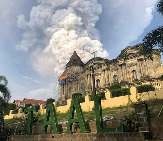
-The major religion in Taal Basilica is Roman Catholic. It is considered to be the largest church in the Philippines. It was destroyed along with the town of Taal in the largest recorded eruption of Taal volcano . This event led to transfer of the town and the church farther away from the volcano to its present site atop an elevated hill facing Balayan Bay. The ruins of the previous church can still be seen in San Nicolas.
-Batangas wedding tradition make a beautiful and exciting feast. Batangueños has high regard for the sanctity of marriage making the event a lengthy and grand occasion.
Ethnic group in Batangas are TAGALOG
-An eruption of Taal Volcano destroyed a significant portion of the town, causing residents to transfer to Bonbon (now Taal), the name eventually encompassing the bounds of the modern province.
-Majority (96.73 percent) of the household population in Batangas classified themselves as Tagalog. The remaining 3.26 percent were either Bicol, Bisaya/Binisaya, Cebuano or belonged to other ethnic groups.
Fiestas and Traditions
Anihan Festival
-Batangas being a place abundant in agricultural produce, the town of Lobo shows their appreciation by celebrating fruits, root crops, and other commodities . The town is known for being the “Atis Capital of the Philippines” so expect the fruit as the main feature in the festival.

-Most of the people, especially the old one’s believes that celebrating their patrons saint day, will give them luck. This is why they are willing to stake their last earned money for a one-day celebration.
-If you have a chance to experience this fiesta, you will notice that everybody is invited. You don’t need to know your host to enter one’s house. They will accommodate you even this is the first time you have met. And treat you as a long time friend.
Tinapay Festival

-One of the fiestas that were cancelled because of the eruption of Taal 2020 is the The Tinapay Festival (Bread Festival) in Cuenca, considered the bakers of Batangas province. It is held annually from February 7 to 13. The patron saint of Cuenca, Our Lady of Peace and Good Voyage is being honored for abundant living and thanksgiving.
-A total of 39 people died as a result of this eruption of Taal, although only one reported case was directly caused by the eruption on January 12, 2020. According to the Manila Bulletin, people either perished because they refused to follow the evacuation order or decided to return to their homes, or died in the evacuation centers of heart attacks caused by anxiety.
Biological profile of the area
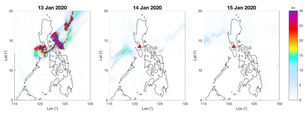
-Along with ash and lava, Taal Volcano in the Philippines is spewing tons of gases into the air.
-One of those gases is sulfur dioxide, which can affect Earth’s climate.
-On January 13, the Philippine Institute of Volcanology and Seismology measured sulfur dioxide emissions at an average of 6,500 tons a day.
-In people, SO2 causes a lot of problems like irritation and affects mucous membranes of the eyes, nose and throat. High concentrations can cause lung inflammation and make breathing difficult.
-Gaseous SO2 can harm a lot of living things like plants and trees, and also it can fall as acid rain which makes it more dangerous and destroys the habitats of the animals and causes more environmental damage.
-Volcanoes also pump sulfur dioxide into the stratosphere, the second layer of Earth’s atmosphere which lowers Earth’s Temperature
( Additional Details from Laurien Reyes )
Here's our work (You may acess it anytime and anywhere)
https://drive.google.com/drive/u/1/folders/1-n6lbTvup9ObSgDvtxYzLNkW611u0-JS